Paradise Camping!
Check out the Best Whistler Hiking by Month for inspiration! We rent the best hiking and camping gear. Tents, sleeping bags, sleeping pads, stoves, packs, complete kits and more!
![]() Mount Sproatt, or as it is known locally as just Sproatt, is one of the many towering mountains visible from Whistler Village. Above and beyond Alta Lake, directly across from Whistler Mountain and Blackcomb Mountain, you will see this quiet giant. Its unremarkable appearance hides the growing network of trails that stretch through some startlingly beautiful terrain.
Mount Sproatt, or as it is known locally as just Sproatt, is one of the many towering mountains visible from Whistler Village. Above and beyond Alta Lake, directly across from Whistler Mountain and Blackcomb Mountain, you will see this quiet giant. Its unremarkable appearance hides the growing network of trails that stretch through some startlingly beautiful terrain.
![]() Alexander Falls
Alexander Falls ![]() Ancient Cedars
Ancient Cedars ![]() Black Tusk
Black Tusk ![]() Blackcomb Mountain
Blackcomb Mountain ![]() Brandywine Falls
Brandywine Falls ![]() Brandywine Meadows
Brandywine Meadows ![]() Brew Lake
Brew Lake ![]() Callaghan Lake
Callaghan Lake ![]() Cheakamus Lake
Cheakamus Lake ![]() Cheakamus River
Cheakamus River ![]() Cirque Lake
Cirque Lake ![]() Flank Trail
Flank Trail ![]() Garibaldi Lake
Garibaldi Lake ![]() Garibaldi Park
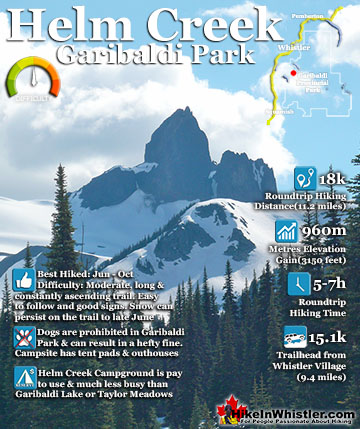
Garibaldi Park ![]() Helm Creek
Helm Creek ![]() Jane Lakes
Jane Lakes ![]() Joffre Lakes
Joffre Lakes ![]() Keyhole Hot Springs
Keyhole Hot Springs ![]() Logger’s Lake
Logger’s Lake ![]() Madeley Lake
Madeley Lake ![]() Meager Hot Springs
Meager Hot Springs ![]() Nairn Falls
Nairn Falls ![]() Newt Lake
Newt Lake ![]() Panorama Ridge
Panorama Ridge ![]() Parkhurst Ghost Town
Parkhurst Ghost Town ![]() Rainbow Falls
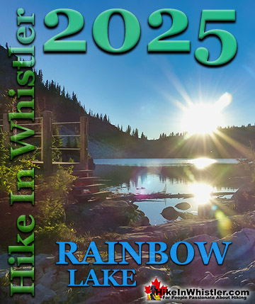
Rainbow Falls ![]() Rainbow Lake
Rainbow Lake ![]() Ring Lake
Ring Lake ![]() Russet Lake
Russet Lake ![]() Sea to Sky Trail
Sea to Sky Trail ![]() Skookumchuck Hot Springs
Skookumchuck Hot Springs ![]() Sloquet Hot Springs
Sloquet Hot Springs ![]() Mount Sproatt
Mount Sproatt ![]() Taylor Meadows
Taylor Meadows ![]() Train Wreck
Train Wreck ![]() Wedgemount Lake
Wedgemount Lake ![]() Whistler Mountain
Whistler Mountain
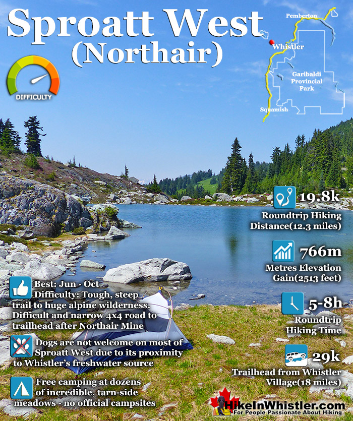
Next time you walk through Whistler Village and cross the pedestrian bridge(with Village Gate Boulevard below you), you will see Mount Sproatt in the distance. It is the rocky giant, abruptly steep on one end and gently sloping on the other. At its summit you may be able to make out the small weather recording structure. What you can't see from Whistler Village is the extraordinarily beautiful alpine paradise that lays beyond it. Lakes and tarns everywhere you look. Fields of alpine flowers and wonderfully mangled, yet strikingly beautiful forests of krummholz. Hostile looking fields of boulders and absurdly placed erratics the size of RV's. Beyond, of course, endless stunning view of distant, snowy mountains. From the towering elevation of much of the trails on Sproatt you often look across or even down on distant mountains. Rainbow Mountain looks incredible from much of the trail. Four teeth-like, jagged grey peaks in a row that face you from Rainbow Mountain, just 5 kilometres away look enormous. A couple kilometres closer you spot Hanging Lake and the Lord of the Rings style valley that stretches 2 kilometres from its shores to the abrupt cliffs at your feet. Several times along the trail you see the clearly defined ski runs on Whistler Mountain and Blackcomb Mountain and once in a while you can spot Alta Lake and Whistler Village.

There are a several ways to hike to the summit of Mount Sproatt, though two main routes stand out, Sproatt West and Sproatt East. The Sproatt West (Northair) route starts way up in the Callaghan Valley past the old, abandoned Northair Mine. An increasingly brutal 4x4 road extends past the old gold mine for a couple kilometres before ending at the start of the With a Twist trail. With a Twist takes you up into the alpine along a beautiful and very scenic route through the expansive wilderness. After 3.3 kilometres, With a Twist ends at a fork in the trail. Right descends down the mountain towards Function Junction via the Into the Mystic trail. The left fork keeps you in the alpine heading towards the summit of Mount Sproatt along the On the Rocks trail. On the Rocks is 3.6 kilometres long and takes you through more magnificent alpine and past Tonic Peak(1803m). On the Rocks ends at another trail fork. Right leads down toward Function Junction on the Lord of the Squirrels trail. The trail to the left continues on to the Mount Sproatt for 2.5 kilometrs to the summit viewpoint via the Happy Hour trail. The summit viewpoint has a big viewing platform overlooking Whistler Valley. The actual summit of Sproatt is about 600 metres back from the viewpoint and towers over the valley at 1834 metres. Though the viewpoint is a few metres lower in elevation, its position is more steeply overlooking the valley and much nicer.


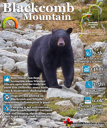
![]() The Sproatt East trail is a beautifully wild, steep, but relatively short trail to the magnificent, wide open alpine and summit of Mount Sproatt. Mount Sproatt (1834 metres) towers over Whistler Valley directly across from Whistler Mountain (2181 metres) and Blackcomb Mountain (2436 metres). There are several routes and trails to access Sproatt and the Sproatt East trail is arguably the shortest and certainly the most convenient from Whistler. The trail begins high up in Stonebridge, the luxurious Whistler neighbourhood that extends up the valley above Alta Lake along the lower part of Mount Sproatt. From the trailhead in Stonebridge to the summit of Sproatt you gain over a thousand metres(3280 feet) in just 5.5 kilometres(3.4 miles). The steepness of the trail is comparable to the trail to Wedgemount Lake where you gain 1220 metres(4003 feet) in just 7 kilometres(4.4 miles). The Sproatt East trail quickly ascends from the Flank Trail into a stunningly varied array of deep jungle-like rainforest, to boulder strewn valleys, to spectacular rock outcrops above the treetops overlooking Whistler Valley. One minute you are hiking over dry, rocky terrain under the hot sun, then suddenly you are enveloped in deep, dark forest with idyllic streams flowing across the trail. Often you round a bend and find yourself facing a vertical wall of rock dozens of metres tall. You find yourself staring in wonder at the staggering size and what the view must be like at the top. The trail tends to bend around the base of these monoliths and almost always leads up to an access route to the top. This is one of the great features of the trail is the seemingly endless array of towering cliffs overlooking Whistler far below.
The Sproatt East trail is a beautifully wild, steep, but relatively short trail to the magnificent, wide open alpine and summit of Mount Sproatt. Mount Sproatt (1834 metres) towers over Whistler Valley directly across from Whistler Mountain (2181 metres) and Blackcomb Mountain (2436 metres). There are several routes and trails to access Sproatt and the Sproatt East trail is arguably the shortest and certainly the most convenient from Whistler. The trail begins high up in Stonebridge, the luxurious Whistler neighbourhood that extends up the valley above Alta Lake along the lower part of Mount Sproatt. From the trailhead in Stonebridge to the summit of Sproatt you gain over a thousand metres(3280 feet) in just 5.5 kilometres(3.4 miles). The steepness of the trail is comparable to the trail to Wedgemount Lake where you gain 1220 metres(4003 feet) in just 7 kilometres(4.4 miles). The Sproatt East trail quickly ascends from the Flank Trail into a stunningly varied array of deep jungle-like rainforest, to boulder strewn valleys, to spectacular rock outcrops above the treetops overlooking Whistler Valley. One minute you are hiking over dry, rocky terrain under the hot sun, then suddenly you are enveloped in deep, dark forest with idyllic streams flowing across the trail. Often you round a bend and find yourself facing a vertical wall of rock dozens of metres tall. You find yourself staring in wonder at the staggering size and what the view must be like at the top. The trail tends to bend around the base of these monoliths and almost always leads up to an access route to the top. This is one of the great features of the trail is the seemingly endless array of towering cliffs overlooking Whistler far below.

Nearing the summit of Sproatt you emerge from the forest and enter a dramatically beautiful, boulder strewn alpine with grassy meadows, tarns, cliffs and endless directions to explore. The marked trail ends abruptly at a large meadow sloping upward toward the summit of Sproatt. There are several steep, but not really difficult routes to the summit and there is even a large viewing platform overlooking Whistler on a cliff near the summit. From the viewing platform and the summit of Sproatt trails extend west over the massive, broad expanse of alpine wilderness. The ever-increasing spider web of trails branch in several directions. Last Call and Happy Hour run roughly parallel west from the viewing platform. Happy Hour connects to Lord of the Squirrels and veers south down to the Flank Trail. Rush Hour continues west connecting to On the Rocks which continues all the way to the Sproatt West trailhead just up from Northair Mine in the Callaghan Valley!

More hiking information for Sproatt click here..
![]() There are several hiking trails and sights to see around the Sproatt Alpine Trail. The Rainbow Trail to Rainbow Falls and Rainbow Lake can be found further along the Flank Trail near Rainbow Park in Whistler. The Madeley Lake trail runs over the top of the Sproatt Alpine Trail and connects Madeley Lake to Hanging Lake and then to Rainbow Lake. Hanging Lake can be reached by and unmarked, though fairly easy alpine route off of the Sproatt Alpine Trail. Northair Mine near the Callaghan Valley end of the trail is a surreal little world in the mountains. There are cement foundations adorned with graffiti, two lakes and all sorts of curiosities to explore. Northair Mine is a great place to camp if you can manage to get your vehicle past the washouts on the bad forest service road to it. Alexander Falls, one of Whistler's most amazing waterfalls to see is easy to drive to, without a 4x4. The Callaghan Valley has several other great places to hike. Callaghan Lake Provincial Park has some short trails at this beautiful lake as well as free campsites. Cirque Lake is a challenging, though short trail that begins at the far end of Callaghan Lake. The Ring Lake trail also starts from near Callaghan Lake Provincial Park.
There are several hiking trails and sights to see around the Sproatt Alpine Trail. The Rainbow Trail to Rainbow Falls and Rainbow Lake can be found further along the Flank Trail near Rainbow Park in Whistler. The Madeley Lake trail runs over the top of the Sproatt Alpine Trail and connects Madeley Lake to Hanging Lake and then to Rainbow Lake. Hanging Lake can be reached by and unmarked, though fairly easy alpine route off of the Sproatt Alpine Trail. Northair Mine near the Callaghan Valley end of the trail is a surreal little world in the mountains. There are cement foundations adorned with graffiti, two lakes and all sorts of curiosities to explore. Northair Mine is a great place to camp if you can manage to get your vehicle past the washouts on the bad forest service road to it. Alexander Falls, one of Whistler's most amazing waterfalls to see is easy to drive to, without a 4x4. The Callaghan Valley has several other great places to hike. Callaghan Lake Provincial Park has some short trails at this beautiful lake as well as free campsites. Cirque Lake is a challenging, though short trail that begins at the far end of Callaghan Lake. The Ring Lake trail also starts from near Callaghan Lake Provincial Park.

")