Paradise Camping!
Check out the Best Whistler Hiking by Month for inspiration! We rent the best hiking and camping gear. Tents, sleeping bags, sleeping pads, stoves, packs, complete kits and more!
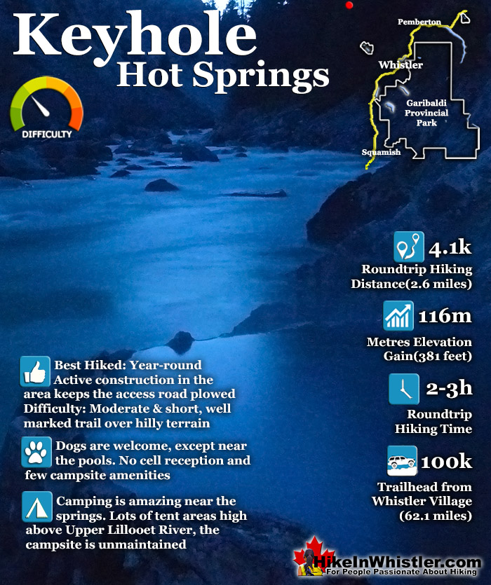
![]() Keyhole Hot Springs (aka Pebble Creek Hot Springs) is located 100 kilometres from Whistler(Village Gate Blvd). Though most of the 100 kilometres is on logging roads, it is driveable by most cars without any trouble. The massive Innergex hydroelectric project has turned this once quiet wilderness into a war-zone. On the plus side, the old logging roads near Keyhole Hot Springs are now well maintained and smooth.
Keyhole Hot Springs (aka Pebble Creek Hot Springs) is located 100 kilometres from Whistler(Village Gate Blvd). Though most of the 100 kilometres is on logging roads, it is driveable by most cars without any trouble. The massive Innergex hydroelectric project has turned this once quiet wilderness into a war-zone. On the plus side, the old logging roads near Keyhole Hot Springs are now well maintained and smooth.
![]() Alexander Falls
Alexander Falls ![]() Ancient Cedars
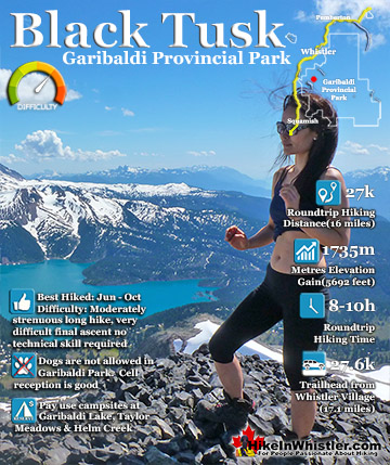
Ancient Cedars ![]() Black Tusk
Black Tusk ![]() Blackcomb Mountain
Blackcomb Mountain ![]() Brandywine Falls
Brandywine Falls ![]() Brandywine Meadows
Brandywine Meadows ![]() Brew Lake
Brew Lake ![]() Callaghan Lake
Callaghan Lake ![]() Cheakamus Lake
Cheakamus Lake ![]() Cheakamus River
Cheakamus River ![]() Cirque Lake
Cirque Lake ![]() Flank Trail
Flank Trail ![]() Garibaldi Lake
Garibaldi Lake ![]() Garibaldi Park
Garibaldi Park ![]() Helm Creek
Helm Creek ![]() Jane Lakes
Jane Lakes ![]() Joffre Lakes
Joffre Lakes ![]() Keyhole Hot Springs
Keyhole Hot Springs ![]() Logger’s Lake
Logger’s Lake ![]() Madeley Lake
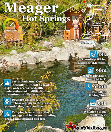
Madeley Lake ![]() Meager Hot Springs
Meager Hot Springs ![]() Nairn Falls
Nairn Falls ![]() Newt Lake
Newt Lake ![]() Panorama Ridge
Panorama Ridge ![]() Parkhurst Ghost Town
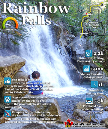
Parkhurst Ghost Town ![]() Rainbow Falls
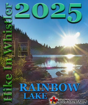
Rainbow Falls ![]() Rainbow Lake
Rainbow Lake ![]() Ring Lake
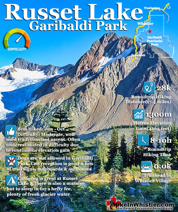
Ring Lake ![]() Russet Lake
Russet Lake ![]() Sea to Sky Trail
Sea to Sky Trail ![]() Skookumchuck Hot Springs
Skookumchuck Hot Springs ![]() Sloquet Hot Springs
Sloquet Hot Springs ![]() Sproatt East
Sproatt East ![]() Sproatt West
Sproatt West ![]() Taylor Meadows
Taylor Meadows ![]() Train Wreck
Train Wreck ![]() Wedgemount Lake
Wedgemount Lake ![]() Whistler Mountain
Whistler Mountain
The hot springs at Keyhole flow out of the ground adjacent to the swirling, crashing and wonderfully glacier coloured water of the Lillooet River. The colour varies with the season, but for the most part it is a wonderful, deep, milky turquoise. When the sunlight penetrates the deep valley, the milky turquoise changes to an unnaturally bizarre, emerald green colour as it swirls all around you. Sitting in the springs you look across to the vertical rock face and the massive, truck sized chunks of it that lay in the river next to you. The Lillooet is fed from various glaciers and snowy mountains visible all the way to Pemberton. At the Lillooet River crossing in Pemberton Meadows take a look in the distance and you will make out the spectacularly jagged and violent looking peak of Mount Meager. It is also a good place to reflect on the fact that Mount Meager produced the larges volcanic eruption in Canada, in the last ten thousand years. It occurred about 2400 years ago and Keyhole and Meager Hot Springs are symptoms of current volcanic activity and another major eruption is possible. For such a remote place, Keyhole Hot Springs have a pretty elaborate hot springs layout as well as a very large(unmaintained) camping area in the deep forest, high above the hot springs about a 10 minute walk away. Signs of semi-permanent tarp dwellings can be seen in stages of ruin, but overall the campsite area is amazing. With the exception of being dark due to the thick forest and fresh water a steep, 5 minute walk away, it is perched on a wonderful cliff with great views of the river below and cliff and mountains and waterfalls across. If the campsite had a dozen tents within it, you could space them out enough to not see or hear each other fairly easily. In the last couple years BC Ministry of Forests and Recreation Sites and Trails BC have been aggressively blocking public access to both Meager Hot Springs and Keyhole Hot Springs. Currently, in 2023 they have blocked both access roads with gates to the trailheads and are threatening to issue violation tickets. The warning reads: SITE CLOSED: Trail and hot springs are closed from Apr 1 to Nov 15 each year (spring to fall) The Province will be enforcing this closure and will issue violation tickets to anyone caught ignoring the restrictions. They don't appear to have any legitimate reasons for the closures and are clearly making up vague things to justify blocking public access. For example: "The Upper Lillooet provides important habitat for many wildlife species, including the threatened South Chilcotin grizzly bear population, and is a very important wildlife migration corridor for deer, moose, and mountain goats. Mineral licks at the hot springs provide wildlife with year-round nutrients. The hot springs are also home to the vivid dancer damselfly, a species of special concern that is threatened by intensive recreational use. Ad hoc water diversion mechanisms and user created tubs disturb natural features and alter stream flow, negatively impacting the ecosystem. Human activity at the hot springs can displace wildlife from these valuable habitat features."

Further down the river, in the opposite direction of the Keyhole Hot Springs is a beautiful and easily hiked stretch of the river, passing waterfalls on both sides of the river as well as some wonderful, potential campsites on sandy and grassy plateaus next to the river(about 15 minutes away). Across from Keyhole Hot Springs and campsite there is a abrupt and massive opposing rock face created from the eruption of Plinth Peak on Mount Meager in 410BCE. Plinth is one of six main summits on Meager, hidden beyond this rock face that looks both impressively huge and wonderfully close. You can actually see trees frozen in time from the last eruption in the face of this cliff. Sticking out, black eroding away with the cliff.

If you find Keyhole Hot Springs closed, Keyhole Falls is just a couple kilometres further on the same road. Just continue driving past the Lillooet River Trail. You will see a large, unmarked parking area and hard to find trail just before the km 50(just before the bridge). If you have doubts that you are parking in the right spot, just get out of your vehicle and listen for a moment. The deep rumbling of Keyhole Falls can be faintly heard from where you park. Climb the gravel embankment(don't cross the vehicle bridge) and look for the faint trail, then follow the faint rumbling from the falls as it soon becomes a thundering echo far below. The trail is just a couple hundred metres long from the parking area. The reason you have to be brave to get to Keyhole Falls is because of the colossal war zone you have to drive through to get to it. It is a bit daunting, however, access to the area is still allowed. You just have to be very aware of being considerate to the massive construction vehicles scrambling to get the job done. There are large signs indicated where you cannot go, which makes navigating to the falls more manageable.
Keyhole Hot Springs Continued...

")