Paradise Camping!
Check out the Best Whistler Hiking by Month for inspiration! We rent the best hiking and camping gear. Tents, sleeping bags, sleeping pads, stoves, packs, complete kits and more!
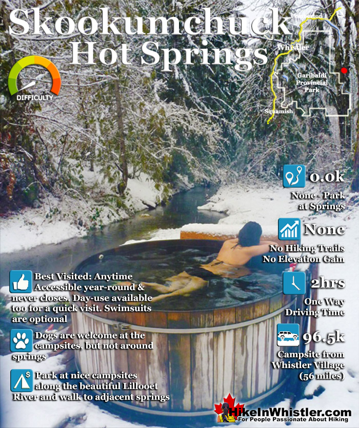
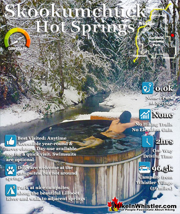
![]() Skookumchuck Hot Springs, located two hours north of Whistler along the edge of the huge Lillooet River. The name Skookumchuck means "strong water" in the language of the Chinook people of the Pacific Northwest. The name is associated with the hot springs because of the nearby First Nation community of Skatin, which was once called Skookumchuck.
Skookumchuck Hot Springs, located two hours north of Whistler along the edge of the huge Lillooet River. The name Skookumchuck means "strong water" in the language of the Chinook people of the Pacific Northwest. The name is associated with the hot springs because of the nearby First Nation community of Skatin, which was once called Skookumchuck.
![]() Alexander Falls
Alexander Falls ![]() Ancient Cedars
Ancient Cedars ![]() Black Tusk
Black Tusk ![]() Blackcomb Mountain
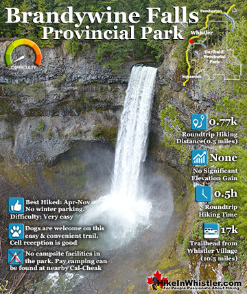
Blackcomb Mountain ![]() Brandywine Falls
Brandywine Falls ![]() Brandywine Meadows
Brandywine Meadows ![]() Brew Lake
Brew Lake ![]() Callaghan Lake
Callaghan Lake ![]() Cheakamus Lake
Cheakamus Lake ![]() Cheakamus River
Cheakamus River ![]() Cirque Lake
Cirque Lake ![]() Flank Trail
Flank Trail ![]() Garibaldi Lake
Garibaldi Lake ![]() Garibaldi Park
Garibaldi Park ![]() Helm Creek
Helm Creek ![]() Jane Lakes
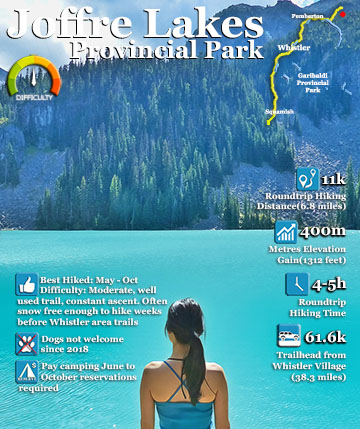
Jane Lakes ![]() Joffre Lakes
Joffre Lakes ![]() Keyhole Hot Springs
Keyhole Hot Springs ![]() Logger’s Lake
Logger’s Lake ![]() Madeley Lake
Madeley Lake ![]() Meager Hot Springs
Meager Hot Springs ![]() Nairn Falls
Nairn Falls ![]() Newt Lake
Newt Lake ![]() Panorama Ridge
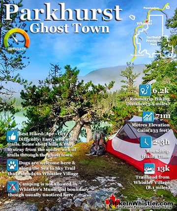
Panorama Ridge ![]() Parkhurst Ghost Town
Parkhurst Ghost Town ![]() Rainbow Falls
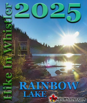
Rainbow Falls ![]() Rainbow Lake
Rainbow Lake ![]() Ring Lake
Ring Lake ![]() Russet Lake
Russet Lake ![]() Sea to Sky Trail
Sea to Sky Trail ![]() Skookumchuck Hot Springs
Skookumchuck Hot Springs ![]() Sloquet Hot Springs
Sloquet Hot Springs ![]() Mount Sproatt
Mount Sproatt ![]() Taylor Meadows
Taylor Meadows ![]() Train Wreck
Train Wreck ![]() Wedgemount Lake
Wedgemount Lake ![]() Whistler Mountain
Whistler Mountain
The Skookumchuck Hot Springs were also once known as St. Agnes Well during the days of the Fraser Canyon Gold Rush, but that name has fallen into disuse. They are also known locally by the Skatin name as the T'sek Hot Springs. Just 20 minutes north of Whistler you pass Nairn Falls Provincial Park. This is a great pit-stop on your way to Skookumchuck. Whether you hike the short, 1.2 kilometre trail to Nairn Falls or just check out the river viewpoint near the parking lot. Back on the highway, Pemberton is just 5 minutes north of Nairn Falls. This little town is your last chance for gas, food, alcohol, ect, as you will shortly be leaving civilization and entering the wilderness around Lillooet Lake. As you drive through Pemberton, just before Mount Currie you will see North Arm Farm on your right. Keep your eye out about 5 minutes past the McDonalds/Petrocan intersection and you will see it. This is a great place to see and wander around the beautiful farm grounds, visit the interesting farm animals and marvel at the amazing view of Mount Currie. The farm is free to visit and open weekends in the winter and everyday the rest of the year. They have a fantastic cafe with all sorts of baked goods and lunch items as well as various farm fresh produce for sale as well. Also, a great place for your last coffee before entering the wilderness.

Another 10 minutes on the highway further and you come to the turnoff to the In-Shuck-Ch Forest Service Road(see directions below) and begin the long and beautiful drive along Lillooet Lake. There are several excellent Lillooet Lake and Lillooet River viewpoints to stop and see along the way. From the obvious and frequent viewpoints along the road to the numerous and inviting campsites along the way. These campsites are great places to stop and see Lillooet Lake, have a beer, swim, or all three. Depending on the season, Lillooet Lake can be emerald, though cloudy green or muddy brown. This is all dependent on the spring runoff and especially the silty brown, Lillooet River that flows into Lillooet Lake from Pemberton. Lillooet Lake flows into the rushing and crashing Lillooet River and Skookumchuck sits at the edge of this beautiful river. Once you see the end of the lake and start driving along the river you are getting close to the hot springs. More information on Skookumchuck Hot Springs...

![]() Keyhole Hot Springs, just a few kilometres up from the old turnoff to Meager, are in an amazingly beautiful setting. There are two cemented tubs into the rock perched on the edge of Lillooet River. These are the most beautiful, however there are several more possible springs to be had close by. There is a fabulous sandy area between the cliff and the river where hot spring water bubbles from the sand. There is a shovel here to dig yourself a beautiful pool and channel river water in as needed to moderate the temperature. There is also a small fire pit as well as several log seats. Keyhole Hot Springs are very popular which can be seen by the elaborate hot springs layout as well as the huge campground area in the deep forest, high above the hot springs about a 10 minute walk away. Signs of semi-permanent dwellings can be seen in stages of ruin, but overall the campsite area is amazing.
Keyhole Hot Springs, just a few kilometres up from the old turnoff to Meager, are in an amazingly beautiful setting. There are two cemented tubs into the rock perched on the edge of Lillooet River. These are the most beautiful, however there are several more possible springs to be had close by. There is a fabulous sandy area between the cliff and the river where hot spring water bubbles from the sand. There is a shovel here to dig yourself a beautiful pool and channel river water in as needed to moderate the temperature. There is also a small fire pit as well as several log seats. Keyhole Hot Springs are very popular which can be seen by the elaborate hot springs layout as well as the huge campground area in the deep forest, high above the hot springs about a 10 minute walk away. Signs of semi-permanent dwellings can be seen in stages of ruin, but overall the campsite area is amazing.

Sloquet Hot Springs is a wonderfully wild set of shallow, man-made pools fed by a small, all natural, and very hot, waterfall. The pools stretch from the waterfall to the large and crashing Sloquet River. The large, spread out campsite for the hot springs lies a short 5 minute walk from the springs. You have to follow a dark and quickly descending trail toward the crashing river. As you near, you can smell the unusual, but kind of nice hot springs scent, and you see steam rising all around you, some steam rising, bizarrely, out of the grass clearing on the edge of the river. On your left a rising cliff, on your right the crashing river.

Meager Creek Hot Springs is located 93k northwest of Whistler, was beautifully developed into gorgeous pools, with a caretaker and usage charge. At its height of popularity, Meager Creek Hot Springs had 30,000 yearly visitors. Unfortunately, due to two recent avalanches it seems unlikely to ever officially reopen. After several years of being closed, access reopened on 2009 with a nice, expensive, new bridge. Only to be dramatically obliterated from another slide in 2010. The access bridge over the Upper Lillooet River which cost nearly a million dollars was wrecked in seconds in 2010. There was considerable wrangling and negotiating to get it built in in 2009, however nothing came of it. For the foreseeable future Meager Creek Hot Springs will only be visited by the brave and determined via the new Harrison Hut Trail. This involves following the new Harrison Hut Trail for 6 kilometres then following an old logging road for 3.5k down to the springs. It is a pretty long route. From the time you leave Whistler to soaking in the hot springs, you are looking at about 5 hours! Still the Harrison Hut Trail is pretty amazing. There is an incredible viewpoint a couple kilometres in that gives you an amazing glimpse of the devastation route.